
About Me
I am a graduate student pursuing MSc. in Robotics, Systems and Control at ETH Zurich. My interests lie in various aspects of field robotics with a particular focus on perception for robots. I am currently a visiting student researcher at NASA Jet Propulsion Laboratory (JPL) working on traversability mapping for offroad environments supervised by Dr. Shehryar Khattak at JPL and Prof. Marco Hutter at ETH Zurich. Prior to this I have worked on projects involving Neural implicit SLAM, high speed motion estimation, Collaborative Visual Inertial SLAM and Lidar guided Object detection. I have had the opportunity to work with a diverse range of sensors ranging from dynamic vision sensor (event camera), RGB/RGBD/Stereo cameras to LiDARs and IMUs. I have experience working on different robotc platforms including flying robots (quadcopters, hexacopters), wheeled ground robots (Polaris RZR Dune Buggy, SuperMegaBot, Clearpath Husky UGV) and legged robots (ANYmal C).
Education
2021 - Present
ETH Zurich, Switzerland
Master of Science (MSc.) in Robotics, Systems, and Control
2017 - 2021
Indian Institute of Technology Kharagpur, India
Bachelor of Technology (B.Tech.) in Mechanical Engineer with Micro-specialisation in Entrepreneurship and Innovation
Internships
Sep 2023 - Present
Perception Systems (347J), NASA Jet Propulsion Laboratory, Pasadena, USA
Master's Thesis
Project: Bird's Eye View Learning for Traversability Mapping of Offroad Environments
Sep 2022 - Feb 2023
Sony RDC, Zurich. Switzerland
Computer Vision Intern
Project: High Speed Motion Estimation using Event-based Vision
May 2020 - Apr 2021
Robot Perception Group, Max Planck Institute for Intelligent Systems, Germany
Bachelor's Thesis (Remote)
Project: Mapping of Archaeological Sites using UAVs
Teaching
Mar 2023 - Jul 2023
Teaching Assistant, Robotics Summer School, ETH Zurich
Teaching assistant for the annual Robotics Summer School organized by RobotX
Research
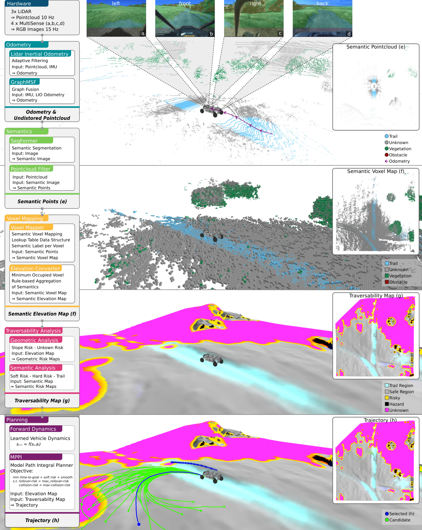
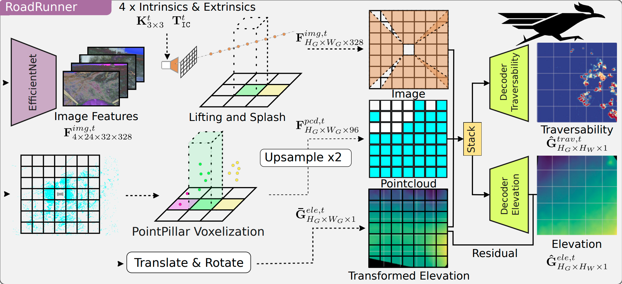
RoadRunner - Learning Traversability Estimation for Autonomous Off-road Driving
Jonas Frey, Shehryar Khattak, Manthan Patel, D Atha, J Nubert, C Padgett, M Hutter, P Spieler
Arxiv preprint
Autonomous navigation at high speeds in off-road environments necessitates robots to comprehensively understand their surroundings using onboard sensing only. The extreme conditions posed by the off-road setting can cause degraded camera image quality due to poor lighting and motion blur, as well as limited sparse geometric information available from LiDAR sensing when driving at high speeds. In this work, we present RoadRunner, a novel framework capable of predicting terrain traversability and an elevation map directly from camera and LiDAR sensor inputs. RoadRunner enables reliable autonomous navigation, by fusing sensory information, handling of uncertainty, and generation of contextually informed predictions about the geometry and traversability of the terrain while operating at low latency. In contrast to existing methods relying on classifying handcrafted semantic classes and using heuristics to predict traversability costs, our method is trained end-to-end in a self-supervised fashion. The RoadRunner network architecture builds upon popular sensor fusion network architectures from the autonomous driving domain, which embed LiDAR and camera information into a common Bird's Eye View perspective. Training is enabled by utilizing an existing traversability estimation stack to generate training data in hindsight in a scalable manner from real-world off-road driving datasets. Furthermore, RoadRunner improves the system latency by a factor of roughly 4, from 500 ms to 140 ms, while improving the accuracy for traversability costs and elevation map predictions. We demonstrate the effectiveness of RoadRunner in enabling safe and reliable off-road navigation at high speeds in multiple real-world driving scenarios through unstructured desert environments.
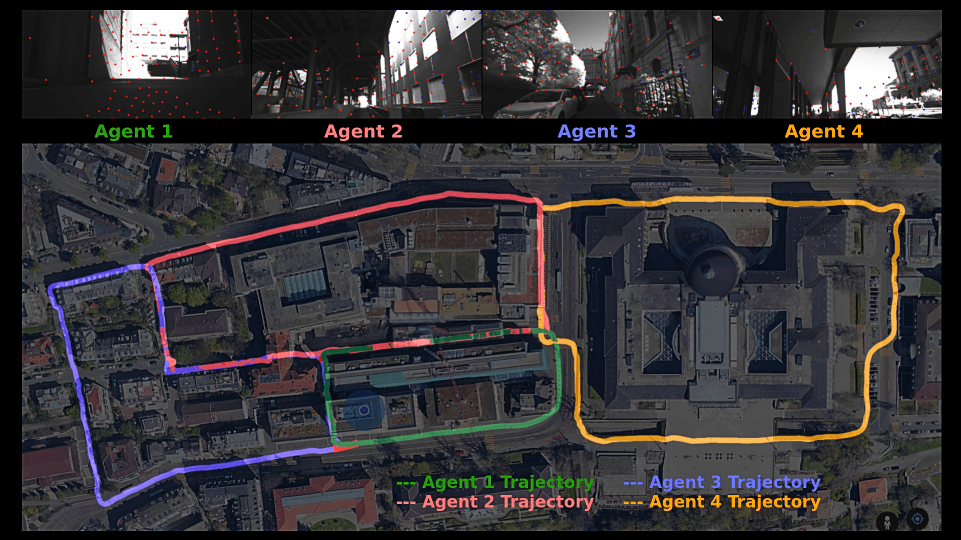
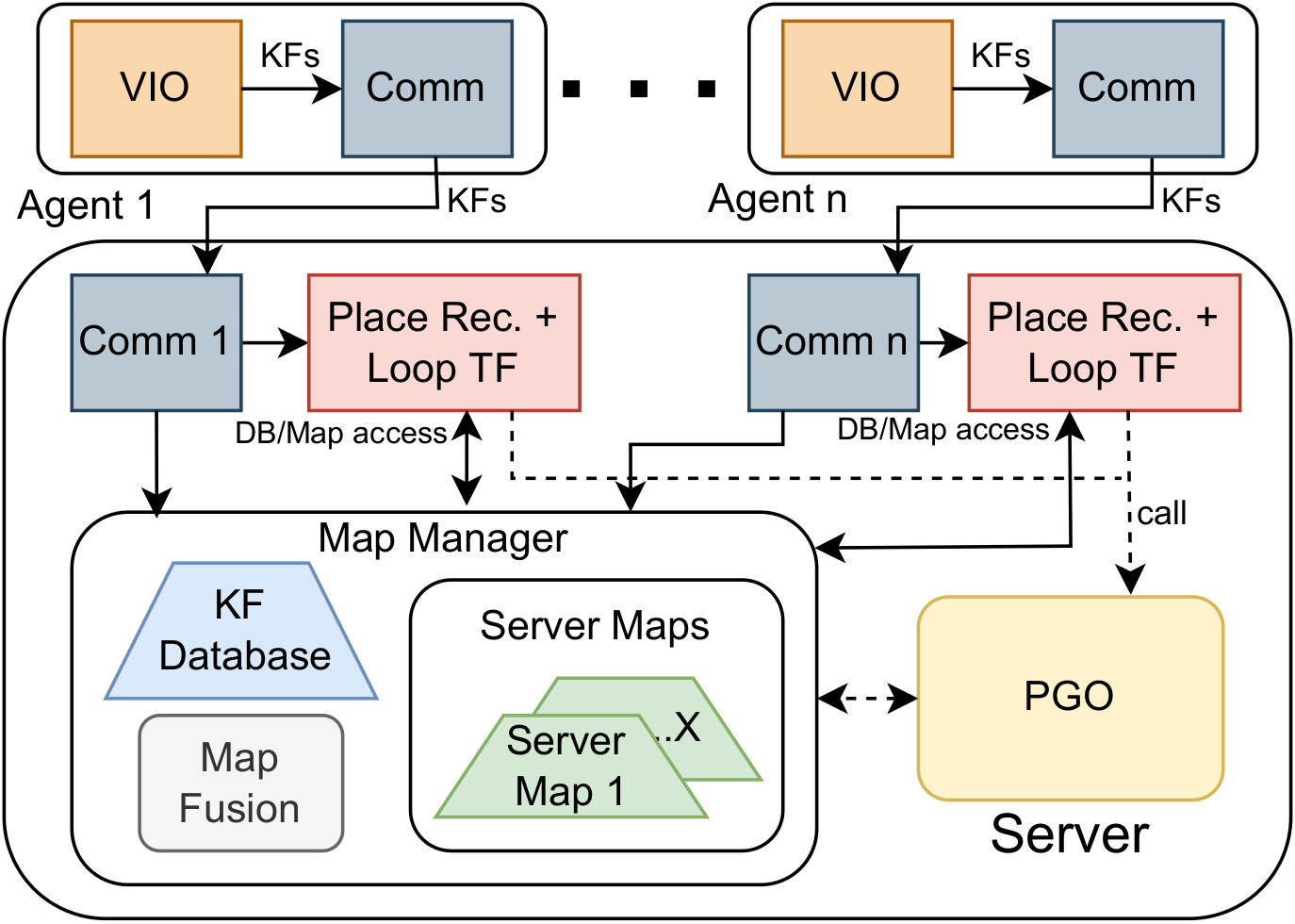
COVINS-G: A Generic Back-end for Collaborative Visual-Inertial SLAM
Manthan Patel, Marco Karrer, Philipp Bänninger, Margarita Chli
International Conference on Robotics and Automation (ICRA), 2023
Collaborative SLAM is essential for multi-robot systems, enabling co-localization in a common reference frame crucial for coordination. Traditionally, a centralized architecture uses agents with onboard Visual-Inertial Odometry (VIO), communicating data to a central server for map fusion and optimization. However, this approach's flexibility is constrained by the VIO front-end choice. Our work introduces COVINS-G, a generalized back-end building on COVINS, making the server compatible with any VIO front-end, including off-the-shelf cameras like Realsense T265. The COVINS-G back-end deploys a multi-camera relative pose estimation algorithm for computing the loop-closure constraints allowing the system to work purely on 2D image data. In the experimental evaluation, we show on-par accuracy with state-of-the-art multi-session and collaborative SLAM systems, while demonstrating the flexibility and generality of our approach by employing different front-ends onboard collaborating agents within the same mission. The COVINS-G codebase, including a generalized ROS-based front-end wrapper, is open-sourced.
[Arxiv] | [Paper] | [Presentation] | [Experiments] | [GitHub]
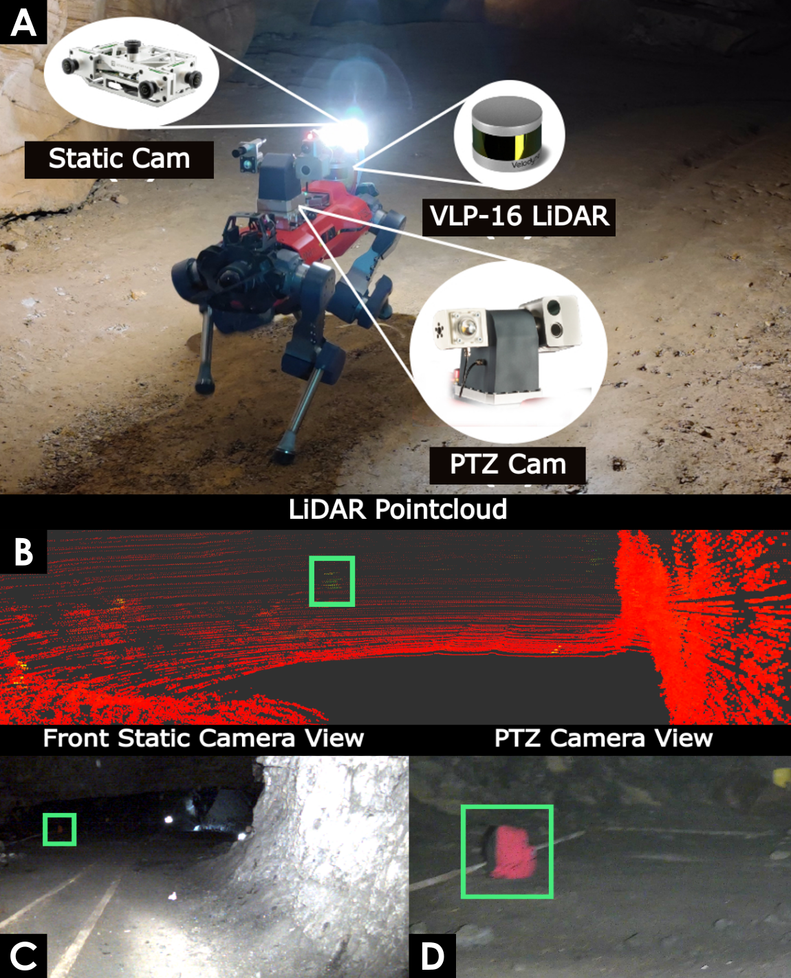
LiDAR-guided object search and detection in Subterranean Environments
Manthan Patel, Gabriel Waibel, Shehryar Khattak, Marco Hutter
IEEE International Symposium on Safety, Security and Rescue Robotics (SSRR) 2022
Detecting objects of interest, such as human survivors, safety equipment, and structure access points, is critical to any search-and-rescue operation. Robots deployed for such time-sensitive efforts rely on their onboard sensors to perform their designated tasks. However, as disaster response operations are predominantly conducted under perceptually degraded conditions, commonly utilized sensors such as visual cameras and LiDARs suffer in terms of performance degradation. In response, this work presents a method that utilizes the complementary nature of vision and depth sensors to leverage multi-modal information to aid object detection at longer distances. In particular, depth and intensity values from sparse LiDAR returns are used to generate proposals for objects present in the environment. These proposals are then utilized by a Pan-Tilt-Zoom (PTZ) camera system to perform a directed search by adjusting its pose and zoom level for performing object detection and classification in difficult environments. The proposed work has been thoroughly verified using an ANYmal quadruped robot in underground settings and on datasets collected during the DARPA Subterranean Challenge finals.
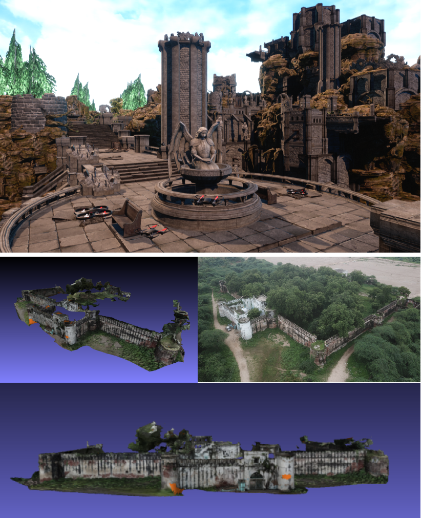
Collaborative Mapping of Archaeological Sites using multiple UAVs
Manthan Patel, Aditya Bandopadhyay, Aamir Ahmad
International Conference on Intelligent Autonomous Systems (IAS 16), 2021
UAVs have found an important application in archaeological mapping. Majority of the existing methods employ an offline method to process the data collected from an archaeological site. They are time-consuming and computationally expensive. In this paper, we present a multi-UAV approach for faster mapping of archaeological sites. Employing a team of UAVs not only reduces the mapping time by distribution of coverage area, but also improves the map accuracy by exchange of information. Through extensive experiments in a realistic simulation (AirSim), we demonstrate the advantages of using a collaborative mapping approach. We then create the first 3D map of the Sadra Fort, a 15th Century Fort located in Gujarat, India using our proposed method. Additionally, we present two novel archaeological datasets recorded in both simulation and real-world to facilitate research on collaborative archaeological mapping. For the benefit of the community, we make the AirSim simulation environment, as well as the datasets publicly available.
Course Projects
Deep Learning for Autonomous Driving: Projects on Multi-task Learning (Semantic Segmentation, Monocular Depth Estimation) and 3D Object Detection using LiDAR data
Vision Algorithms for Mobile Robotics: Implemented a Visual Odometry pipeline from scratch in MATLAB along with local Bundle Adjustment and evaluated the pipeline on 3 different datasets. [Link]
Planning and Decision Making for Autonomous Robots: Implemented an RRT-based global planner and MPC-based trajectory tracking for navigation of a spaceship in simulation. [Link]
Probabilistic Artificial Intelligence: Projects on: 1) Bayesian Neural Network for classification on MNIST dataset, 2) Constrained Bayesian Optimization using Expected Improvement as the Acquisition function, 3) Advantage Actor Critic method for learning policy to land spaceship in a simulation environment
Awards and Achievements
Sep 2023 - Apr 2024
JPL Visiting Student Research Program
JPL Visiting Student Research Fellow for conducting my master's thesis at NASA JPL, Pasadena, CA
Sep 2021 - Mar 2023
ETH D-Mavt Scholarship
Full, merit-based scholarship awarded to less than 2.5% of all D-Mavt Masters students at ETH Zurich
Dec 2021
Dr. B C Roy Memorial Gold Medal
Adjudged best all-rounder (Academic and extra-curriculars) among all graduating (1400) B.Tech students at IIT Kharagpur
Dec 2021
Institute Silver Medal (Academic Rank 1)
Highest Cumulative Grade in Mechanical Engineering among all graduating B.Tech students at IIT Kharagpur
Apr 2020 - Dec 2020
DAAD WISE Scholarship
Recipient of the prestigious scholarship to perform a research internship at a German Research Institute (MPI-IS)
2018 - 2020
Inter-IIT Tech Meet 7.0, 8.0 and 9.0
Represented IIT Kharagpur three consecutive times in Inter-IIT Tech events for problem statements invovling autonomous agricultural robot, multi-UAV search mission and UAV-based Sub-terranean exploration mission.
Results: Second Runner Up (2018), First Runner Up (2019) and Winner (2020)
Oct 2020
OP Jindal Engineering and Management Scholarship
Recipient of the scholarship awarded to 100 students across India for academic and leadership excellence
Jun 2019
27th Intelligent Ground Vehicle Competition (IGVC)
Secured the second position in the AutoNav Challenge among 40+ participating international teams at Michigan, USA